2 Hortham about 9 K or 5.6 miles long
The name Hortham suggests that the hamlet might have something to do with Horwood, the mediaeval Royal Forest, disafforested in 1228, which stretched from the Bristol Avon to the Berkeley Avon and from The Severn Shore to the Cotswold Edge. “Horwood” means “Muddy Wood” and Hortham Wood can be exquisitely muddy, so it is not impossible that a muddy “ham” – Horham perhaps – has picked up a “t” to make the name trip better off the tongue.
To get to the start, take the T1 bus from Rock Street to the Swan bus stop in Almondsbury.
https://www.komoot.com/tour/1979448113
Go up The Hill at the north side of the Tump behind the bus stop towards a row of pine trees at the top.
Follow the road to the left between some driveways to a kissing gate into Windmill Field and follow the right hand hedge to another kissing gate into Crantock Drive.
Go straight ahead down the road to a gate into another field.
Note Woodlands Wood over to the right. This wood, which has been split by the motorway, gives its name to Woodlands Golf Course on the other side.
Follow the left hand hedge to a kissing gate leading to a tarmac path down to a tunnel under the M4.
Follow the path straight across the field to a kissing gate onto the Hortham Village estate. Join the yellow gravel path that goes anticlockwise through the arboretum around the new Hortham village. Turn right just past a metal safety fence to emerge on a circular area that would make a cricket pitch if it were a bit bigger. Head past a red dog bin on the far side to access Hortham Lane.

The new village has been built on the site of the old Hortham Idiot Colony, which was infamous for housing John Straffen before he became a child murderer (pictured). He was at one time the longest serving prisoner in the UK. The real mystery is why, with an IQ of 58 and evidence of brain damage suffered as a child he was regarded as fit to plead.
Forests have always been unofficial places of refuge for people as well as for animals; but from the nineteenth century onwards, it has been thought appropriate to establish institutions for those who are needy in some way outside the city in a sylvan setting. Many of these were privately owned, but this one was set up by the local authority under the Mental Deficiency Act of 1913, which enacted the recommendations of the Royal Commission that distinguished between idiots, imbeciles, mental and moral defectives on the advice of the Reverend Harold Burden who set up the Royal Victoria Homes in Bristol.
Turn right on Hortham Lane and then left on a bridle path a hundred yards after Hortham Farm just on the embankment just before you reach the motorway bridge.
On the right, you pass the Quarters, Bristol Rovers Almondsbury Training Ground. Hortham Farm on the left is a two hundred acre arable farm that also welcomes caravans (if you are a member of the Caravan Club.) There is also a secure enclosure for storing caravans in Hortham Wood, which also has a circuit of private paths for caravan customers. There are also facilities for Wood Camping and SG Forest Schools. Whatever the etymologists say, Hortham Wood certainly feels like part of Horwood Forest.
Follow the path around the right hand edge of the field alongside Hortham Brook. Turn right on the access road to the caravan enclosure and then left on the bridleway between Hortham Wood and the perimeter fence of the caravan enclosure.
At the T-junction turn right past the end of the enclosure. Turn left after you cross the sleeper bridge over Hortham Brook. Turn left and follow the grassy ridge between Hortham Brook on the left and a newish plantation on the right to a kissing gate near the motorway.
At this point, Hortham Brook marks the eastern pale of Tockington Park. In general a park pale can be recognized by the ditch on the inside and the bank on the outside. Often, as in this case, the park designer made use of natural features, such as streams, which saved labour.
Through the kissing gate, continue alongside Hortham Brook, with the M5 on your right, over a footbridge with stiles and past concrete footbridge over the motorway until you come to a stile into a field.
The field is now used as a motorbike track as well as grazing for horses and cattle. You need to follow the left hand hedge as best as you may until you reach a footbridge with stiles. Go over the footbridge and turn left up the hedge side to a kissing gate into another field.
Up to this point, you are still following the pale of Tockington Park.
Over the stile, the path heads for the diagonally opposite corner of the field. Go over the footbridge with stiles next to the right hand gate and head straight across the field to a stile by the gate onto a cutoff section of Church Road, which is to the left of a large white house.
On the left as you approach the road stood the Royal Manor owned by King Harold before 1066, which was confiscated by William the Conqueror as spoils of war. For Harold, Alveston was a handy resting place on the way to the ferry to Portskewett in Gwent. William Rufus, the Conqueror’s son, also stayed here. There was certainly a Royal Deer Park associated with the manor and probably the Forest too.
Turn left to join the main road and note the remains of Old St Helen’s Church on the left
There are two St Helens’ churches on this route. A ruined one – only the tower remaining – on Church Road and one on the A38 in Alveston. There are also two Saint Helens. One was Helena, the wife of Constantius Chlorus and the mother of Constantine the Great, the first Emperor of Rome to make Christianity the official religion. She is credited with finding the True Cross (pictured). The second was the wife of Macsen Wledig (Magnus Maximus), who lived about sixty years later. She is celebrated in “The Dream of Macsen Wledig” – a traditional Welsh Tale in the collection known as the Mabinogion. She had a son called Custennin (or Constantine) and is frequently confused with the other Helen. She is often referred to as St Elen of Caernarfon to distinguish her. The Roman Roads in Wales are called Sarn Helen (or Elen) after her. She is also called Elen Luyddog – “Helen of the Hosts.”
It is quite possible that Harold dedicated the church to Elen Luyddog rather than Helena, mother of Constantine, because of a romantic attachment to his Welsh conquests. Alternatively, the dedication could reflect knowledge of Roman remains at Tockington Park.
Cross Old Church Road when you reach a board advertising the five star accommodation at Old Church Farm to a gate into a field.
Follow the right hand hedge through two fields.
In the first field , you pass one of the sinkholes that are characteristic of this area. The path follows the northwest pale of Alveston Deer Park. A nearby farm is called Lawnes Farm, which implies a clearing in a forest. “Loans” is probably a corruption of Lawnes.
In the third field, head for a path to the left of a large house ahead, called the Loans.
Follow the path through the trees to emerge on Forty Acre Lane.
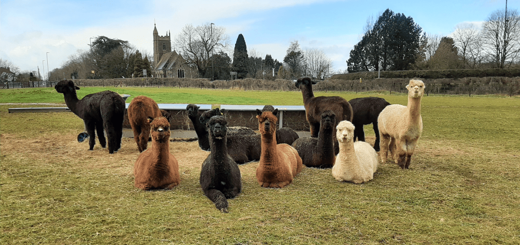
On the other side of the lane is the Wolfridge Alpaca Farm, which houses an excellent cafe. It produces coffee and food of such quality that you may find it difficult to get a seat. Wolfridge Wood is on the other side of the A38, where the farm grazes more Alpacas.
If you have not visited the Alpaca Farm, turn left up the lane to Gloucester Road and use the inconveniently placed pedestrian crossing to reach the new St Helen’s Church.
Go up Greenhill Road to Down Road and turn right to reach the Ship Inn.
This is the quickest way to get back to Thornbury. But if you have been to the cafe, you may well feel so refreshed that you fancy a longer route.
The Ship is a grade II listed coaching inn, built as a farmhouse in 1589. Its most famous customer was probably Dr Jenner of Berkeley who debated vaccination against smallpox here with other local doctors at their regular meetings.
From the Ship, turn left down the hill. You can avoid the unpleasant route alongside the road, by taking the path down through the fields on the right by using the stone stile past the Old Gloucester Road.
The path goes through Ambience Paddock, a smallholding with cattle, sheep and pigs. Some of the cattle look off-putting but are very placid.
The path comes out at the back of Thornbury Leisure Centre. Head clockwise around the Leisure Centre. Cross over the entrance drive to the bus stop. Cross the road into the drive leading to the Golf Course. Just before you enter the golf course, turn right over a stile.
Follow the enclosed path past some primitive sheep to emerge in the Mundy Playing fields. Turn right beside the enclosed football pitch Head past the play park on a tarmac path that leads up past a brick wall into The Close. When you reach the High Street, turn right and then left into Chapel Street. At the end of Chapel Street, turn left along Rock Street, where you caught the bus.
