1 Eastwood about 8 K or 5 miles long.
Eastwood Park is in Falfield, only a short bus ride outside Thornbury, but in the past it was actually in Thornbury Parish. It now houses a women’s prison, where previously it was the home of a Prime Minister.
Get to the start take the number 60 or 62 bus from Rock Street to the Huntsman bus stop in Falfield.
From the bus stop walk back past the war memorial and the church towards the eponymous pub and turn right up Sundays Hill Lane.
On your right is the Parish Church of St George, Falfield. Until 1863, Falfield was part of the ecclesiastical parish of Thornbury. Locals had to make do with a small chapel of ease without an altar, but in 1855 the estate devolved onto Sir George Jenkinson Bart, who built a new manor house and donated land to build a new church, which is dedicated to Saint George, presumably in Jenkinson’s honour, rather than that of the St George who was a Megalomartyr according to the Eastern Orthodox Tradition..
Go past Church Avenue on your left.
The lodge house, pillars and railings signal the fact that this used to be one of the entrances to the Eastwood Park Estate, which belonged to the Jenkinson Family, one of whose number was the Second Lord Liverpool, who was Prime Minister from 1812 to 1827. (This may be why the Eastwood Estate was not involved in the Great Poaching incident of 1815/16.)
The road now leads to HMP Eastwood, a women’s prison which received a shocking report from the prison inspectors in 2023.
Continue along the road until you come to the second footpath on the left (opposite another footpath joining from the right.
Turn left through a kissing gate into the Eastwood Prison Estate. Turn right over a footbridge, then keep right around the field to pick up an enclosed path at the end of a car park, which leads to a footbridge into a field.
In the middle ages, Eastwood was one of two deer parks in Thornbury. The other was Marlwood. The deer park by the Castle was a later addition.
Turn left and follow the newly enclosed path alongside the ditch on the left. Keep going past some farm buildings on the left. Go over a stile and continue along the enclosed path.
At the end you must turn left over a bridge to a gate into a field. Turn right and follow the right hand hedge past another field gate. After you pass some newly planted and fenced trees to an enclosed and gated path through a band of mature trees ahead.
In the next field, bear left to cut the corner of the next field past a dead oak tree to a double stile in the fence ahead.
There are several ancient oak trees in the estate, but they are not next to the footpath.
Head diagonally up the next field towards the wind turbine peeping over the hill. There is a difficult and redundant stile in the top left corner with a kissing gate beyond it.
Go through this gate and another kissing gate on the other side of a muddy track. This brings you into the field containing the wind turbine. You are now back in the modern parish of Thornbury.
The path goes diagonally across the field on a path that goes closer to the wind turbine than the route shown on most maps. The path has been diverted to go through a new kissing gate.
Through the kissing gate, follow the right hand hedge down the hill to another kissing gate.
When there are sheep in this field, they are fenced in by electric fences. If this is the case when you get there, turn right on the farm track and then left between the wire fence on the left and a wood on the right.
In the corner by an impressive oak tree,, there is a kissing gate.
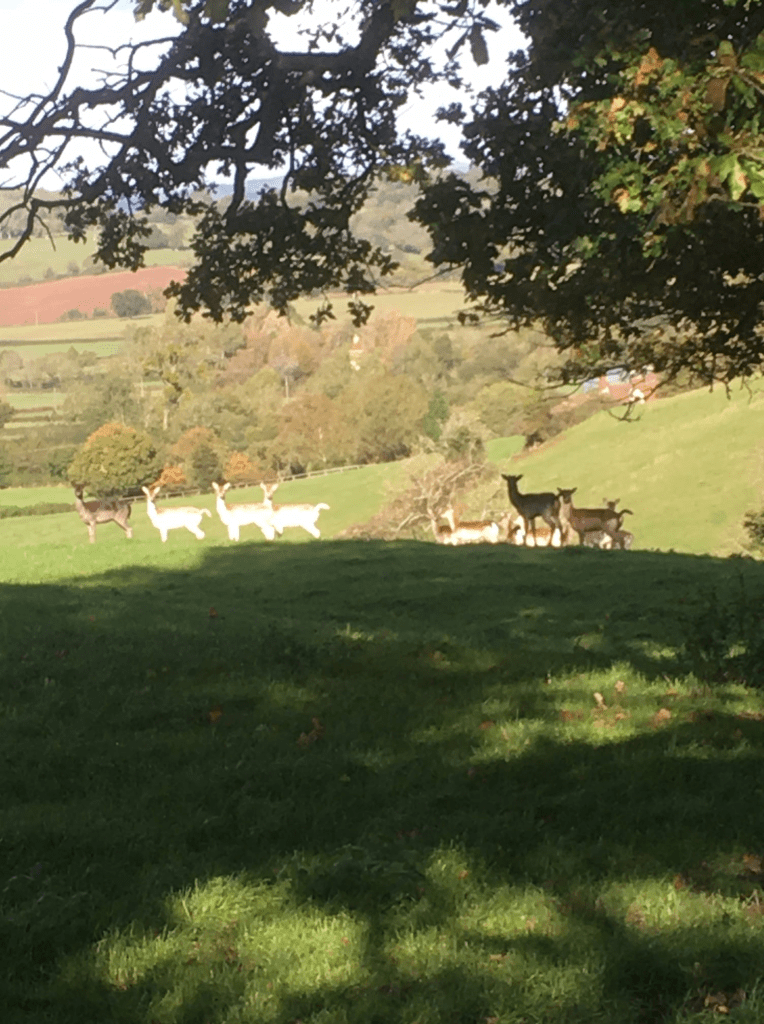
This is a special spot for me, because during or shortly after lockdown I encountered a herd of fallow deer here. There was a white fallow buck and a white doe and a group of varicoloured deer ranging from black to conventionally spotted. The bulk of the herd was through the kissing gate in the field dominated by Camp Hill, an iron age hill fort.
From this spot on the boundary between Thornbury and Rockhampton parishes, you can just about make out, on the far side of the Severn, on another Camp Hill in the grounds of Lydney Park, the site of the ancient temple of Nodens, the father of Gwyn ap Nudd, the Welsh equivalent of Herne the Hunter. Also on this line of sight are the Church of St Michael at Hill and that of St Oswald at Rockhampton.
The temple is to the right of a dip in the distant hills.
Through the kissing gate descend the hill below the rampart to a group of poplars that conceal two new kissing gates separated by a bridge over another gully.
This is the pre 1980s parish boundary between Thornbury and Rockhampton.
In the next field, head towards some white buildings which are beside the tower of St Oswald’s Church hidden by some trees. There is another new kissing gate.. In the next field,follow the left hand hedge until you reach another gate.
St Oswald was a christian king of Northumbria, who was defeated by Penda, the last great pagan king of Mercia, who was allied to various supposedly christian Welsh princes. This took place at Oswestry, where parts of Oswald were displayed on an ash tree as a sacrifice to Woden.
Through the gate, turn left and follow the left hand hedge to the end of the field. There are two stiles in the corner, the first of which I found difficult to get over with an artificial hip, but there is a pleasant grassy path through Mount Pleasant Tree Farm to Gully Road.
Turn left then right towards Luce’s Farm. After some trees on the right, leave the drive and follow the right hand hedge through three field boundaries. The first, which is the old boundary between Rockhampton and Thornbury, has a dog proof stile and the second, on the new boundary, has two dog-proof stiles and a bridge. The third has a similar stile and a kissing gate.
After the second you are briefly back in Thornbury parish.
After the third, ignore a broken stile and plank bridge on the right, and follow the hedge and ditch on the right.
Here you are following the western pale or boundary of the former Eastwood deer park. On the left is a wood called Longman’s Grove, which appears to be managed as a pheasant shoot. You may spot a platform in a tree on the right, which is designed as a hide for those who wish to shoot or photograph the roe and fallow deer that inhabit the wood.
Just before you come to the end of the field, you should find a footbridge guarded by stiles on the right.
As you cross the bridge you are leaving the former Eastwood deer park.
Go straight across the field keeping parallel to the hedge on the right at first, then continuing on the same line to a stile in a projecting corner of the hedge ahead. Be guided by two prominent conifers behind it.
Continue to a stile leading a plank bridge onto the Gloucester Road.
Be careful.
It is probably best to cross the road onto the opposite verge and turn right, although the . verge is higher than it was due to ditch clearing work!
Turn left onto a minor road.
When the road bends to the right, go straight ahead into a field. Bear right across the field to a pair of stiles beside the gable end of a house.
Go straight on down the cul-de-sac and cross Badger Road onto a path alongside a Teletubbies Park through to Morton Way.
Use the pedestrian lights on the left to cross the road onto a path between the houses. This will bring you through to a green open space. Turn right on the grass past the play area. When you come out on the road, go straight ahead down Swallow Park and onto the path leading out onto Gloucester Road.
Cross the road using the traffic island.
The Anchor pub is on your left if you are interested and the timing is right!
Otherwise go straight ahead up the path with Morton Millstream on the left. Take the second bridge over the stream on your left.
Continue along the enclosed path until you emerge over a stone stile onto Park Road. Turn right and follow the footway past Manorbrook Primary School. The footway will take you to an underpass beneath Park Row, which leads to a Streamside Path between the stream and the headquarters of the First Thornbury Scout Group.
The Scout hut is on the site of the former Thornbury Gas Works.
Follow the Streamside Walk past the site of the former Sewage works back onto Gloucester Road.
Use the zebra crossing to find the next section of the Streamside Walk.
Note the former workhouse on the left.
At the end of this stretch of the Streamside Walk, near a rubbish bin, turn right. You can either go up the slope into the playing field or around the path behind the houses. (You may not have a choice for long if the site is developed. )
At the other side of the field, take the enclosed path through to Hillcrest. Turn left and then right into Crispin Lane, which leads to Pullin.s Green, from which you should be able to see Rock Street car park and the St Mary Centre.
